• Welcome to your new Gnomio site

    Now, you are in control!

    Moodle is an open-source Learning Management System (LMS) that provides educators with the tools and features to create and manage online courses. It allows educators to organize course materials, create quizzes and assignments, host discussion forums, and track student progress. Moodle is highly flexible and can be customized to meet the specific needs of different institutions and learning environments.

    Moodle supports both synchronous and asynchronous learning environments, enabling educators to host live webinars, video conferences, and chat sessions, as well as providing a variety of tools that support self-paced learning, including videos, interactive quizzes, and discussion forums. The platform also integrates with other tools and systems, such as Google Apps and plagiarism detection software, to provide a seamless learning experience.

    Moodle is widely used in educational institutions, including universities, K-12 schools, and corporate training programs. It is well-suited to online and blended learning environments and distance education programs. Additionally, Moodle's accessibility features make it a popular choice for learners with disabilities, ensuring that courses are inclusive and accessible to all learners.

    The Moodle community is an active group of users, developers, and educators who contribute to the platform's development and improvement. The community provides support, resources, and documentation for users, as well as a forum for sharing ideas and best practices. Moodle releases regular updates and improvements, ensuring that the platform remains up-to-date with the latest technologies and best practices.

    Links of interest:

    (You can edit or remove this text)

Available courses

General Description of the Course: Levelling Survey

Levelling Survey is a fundamental course in the field of land surveying and civil engineering. It introduces trainees to the principles, methods, and instruments used to determine the relative heights (elevations) of points on the earth's surface. The course emphasizes accurate measurement and data recording to ensure correct elevation profiles, which are essential for designing infrastructure such as roads, bridges, drainage systems, and buildings.

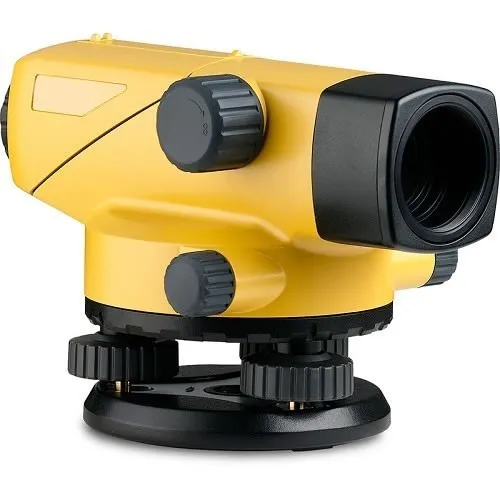
The course trains students to use levelling equipment such as the dumpy level, automatic level (auto level), levelling staff, and related accessories. Practical skills, including setting up instruments, taking readings, and performing arithmetic calculations, are core components of the training.


Course Summary of Levelling Survey

Course Title Levelling Survey
Course Duration 1 Term (varies by institution)
Target Learners Diploma and Certificate students in Building Technology, Civil Engineering, and Surveying
Prerequisites Basic Mathematics and Introduction to Surveying
Course Objectives To equip learners with the skills and knowledge required to carry out levelling surveys accurately and efficiently.

Key Topics Covered

  1. Introduction to Levelling

    • Definition and importance of levelling

    • Types of levelling: differential, profile, cross-sectioning, fly levelling, and reciprocal levelling

  2. Levelling Instruments and Tools

    • Description and use of dumpy level, auto level, and staff

    • Temporary adjustments and handling of instruments

  3. Principles and Methods of Levelling

    • Concepts of line of sight, back sight (BS), intermediate sight (IS), foresight (FS)

    • Booking methods: height of collimation and rise & fall

  4. Field Procedures

    • Setting up instruments and benchmarks

    • Recording data in field books

    • Reducing levels and checking for errors

  5. Levelling Calculations

    • Arithmetic checks

    • Drawing longitudinal and cross-sectional profiles

  6. Practical Sessions

    • Hands-on training in real field conditions

    • Group assignments and project-based learning


Learning Outcomes

By the end of the course, the trainee should be able to:

  • Set up and use levelling instruments correctly

  • Conduct different types of levelling surveys accurately

  • Record and compute elevation data using standard methods

  • Interpret levelling data for use in construction and civil engineering projects

  • Observe safety and professional ethics in the field

Course Summary: Essential Skills

The Essential Skills course focuses on foundational competencies necessary for personal, academic, and professional success. These skills are transferable across different careers and industries, enabling individuals to adapt to various work environments.

Key Learning Areas:

  1. Communication Skills – Effective verbal and written communication, active listening, and professional etiquette.
  2. Problem-Solving & Critical Thinking – Analyzing situations, decision-making, and logical reasoning.
  3. Time Management & Organization – Prioritizing tasks, meeting deadlines, and improving productivity.
  4. Teamwork & Collaboration – Working effectively in teams, conflict resolution, and leadership development.
  5. Adaptability & Resilience – Managing change, emotional intelligence, and stress management.
  6. Workplace Ethics & Professionalism – Integrity, responsibility, and respect in a professional setting.
  7. Basic Digital Literacy – Utilizing technology and digital tools for efficiency.

Course Benefits:

  • Enhances employability and career readiness.
  • Builds confidence in handling workplace challenges.
  • Provides essential tools for continuous personal and professional growth.

This course is suitable for students, job seekers, and professionals looking to strengthen their core competencies for success.